Fast, smart and accurate scanning of Amsterdam’s quay walls
The municipality of Amsterdam has a large number of historic bridges and quay walls in need of maintenance. These structures often form vital links in the urban network and are essential to the city’s functioning. Because research has shown that some of them are reaching the end of their lifespan, the municipality is investing heavily in monitoring and closely observing the bridges and quay walls. With the ‘Bridges and Quay Walls’ programme, the municipality of Amsterdam is inspecting, monitoring and strengthening 829 traffic bridges and 205 linear kilometres of quay walls. Safety, accessibility and quality of life are the fundamental guiding principles.
Currently, bridges and quay walls are mainly monitored using the traditional method of tachymetry and levelling. Due to limited capacity and budget, approximately 10% (20 kilometres of quay walls and 80 bridges) of the total area is inspected annually. However, the remaining area is not without risk, and the municipality of Amsterdam considers it necessary to gain insight into the technical condition of the entire area. Furthermore, it would be desirable to monitor a number of high-risk bridges and quay walls more frequently.
To meet this challenge, the municipality of Amsterdam, in collaboration with the Ministry of Economic Affairs and Climate Policy (EZK) and the Netherlands Enterprise Agency (RVO), launched an innovation competition in the form of an SBIR (Small Business Innovation Research). This SBIR task consisted of 2 phases: designing and developing the (feasibility of the) innovation (phase 1) and demonstrating the innovation in practice (phase 2). In their proposal, contenders also had to consider how their innovative solution would help optimise the costs, speed and capacity required to collect, process and distribute the monitoring data. From the approximately 50 ideas submitted for phase 1, a committee selected eight parties to conduct a feasibility study. These eight feasibility studies were evaluated, and four parties were selected to test their innovation at pilot sites in the municipality of Amsterdam.
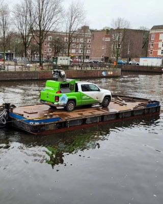
Iv registered for phase 1 to demonstrate the innovative concept of scanning quay walls using a 3D scan car on a pontoon, including internal data control using multiple scanners. During the scanning process, the quay walls are divided into ’tiles’ scanned at hundreds of points, creating a reliable representation of the quay walls and any deformations. The municipality of Amsterdam saw enough merit in Iv’s innovation to allow Iv to be one of the four parties to move on to phase 2: demonstrating the innovation in practice.
Participating in this SBIR serves as a good test case for applications other than quay walls – an innovative challenge where acquired knowledge and expertise can be put into practice.
How exactly does Iv’s method of scanning quay walls work? Iv built the 3D scan car in 2015. Using three laser scanners, this vehicle can quickly and accurately map all types of environments, such as bridges, roads, and dikes, as well as quay walls. The three scanners together increase the reliability of the measurements. Each scanner measures a million points per second. But the chance of them measuring precisely the same points is practically zero. For this reason, the quays are divided into grid cells (tiles) measuring 20 by 20 centimetres. The scanners measure more than 100 points per cell and then calculate the average of all these points to determine the exact position of the tile. When this is performed over an extended period, the deformation of a quay wall (changes in shape and/or size) can be determined.
The 3D scan car, which, when scanning quay walls, is placed on a pontoon for navigating the Amsterdam canals, is equipped with an internal control system; the three laser scanners independently measure the position of the pontoon, which is then compared with the position calculated from GPS measurements and the IMU (Inertial Measurement Unit). With this information, we can improve the position determination and detect deformations of at least 8 millimetres with 95% certainty. This idea was patented by Iv in 2017.
The 3D scan car combined with this internal control is much more reliable than, for example, measuring with GPS alone, which is accurate to within about 2.5 centimetres. With such margins, it is difficult to determine whether something is happening to the quay wall (deformation) or whether something is amiss in the position determination. The internal control provides a more reliable representation. In addition to the accuracy of the calculations, the speed of this measurement method is also an advantage. Amsterdam is home to a vast area of quay walls, and as previously mentioned, only about ten percent of this area can currently be measured yearly. With this innovative method, the entire area could be measured several times a year at a lower cost.
A valuable addition to this trial in Amsterdam is DREAM® (Data-driven and Risk-driven Enterprise Asset Management). This methodology and associated software developed by Iv focuses on accurately predicting the maintenance and maintenance budget of assets by achieving an optimal balance between the area’s performance, risks and costs.
To do this, as much data as possible is collected on the area, and the potential failure mechanisms are analysed using an FMECA database that Iv has built up over the past decades. Combined with recent data on the condition of the area, in this case, the scans of the quay walls in Amsterdam, this can be translated into a probability density function for the moment of failure. By matching this information with the municipality’s corporate values, a risk profile is created for each asset over time, using the colours of the corporate values matrix. This makes it clear at a glance when the risks for the manager shift from ‘acceptable’ to, for example, ‘undesirable’ and ultimately ‘unacceptable’ so that a recommended and latest time for maintenance can be determined.
The elegance of the method is that it also works the other way. That is, based on a desired risk profile, we can calculate over time the extent to which additional information is required for optimal data-driven and risk-driven considerations. This is particularly the case for assets where the expected moment of failure is highly uncertain due to a lack of knowledge about the asset’s condition. By estimating the reduction in knowledge uncertainty resulting from asset condition data collection, such as inspection, load testing or sensor data, Iv determines the so-called value of information of each form of data collection in terms of risk reduction. By comparing this information value with the cost of the data collection method, a simple calculation can be made as to whether it is worth the effort (or money) to collect additional data and, if so, which form of data collection is the most efficient. And if so, with what frequency and accuracy? In this way, DREAM provides not only optimal maintenance planning but also an optimal measurement and monitoring strategy.
Arno, managing director Asset Management, would be delighted to discuss this with you! Get in touch via +31 88 943 3200 or send a message.
